Index
All 83
Allot 77
Allot Gdns 11, 21, 74, 75, 96
Athletic Ground 23
BP 54, 59, 62
Bridge 5, 37, 40, 83
BS 34, 61
BSs 62, 91
Cemetery 33, 91
Cemy 8, 34, 44, 69, 96
CH 11, 23, 50, 59, 79, 83, 100
Coll 75
College 30, 43
Common 32
Ct 87
Downs 59
F Sta 22, 46
Farm 8, 30, 40, 70, 80, 94
FB 3, 4, 7, 14, 17, 18, 45, 95
FBs 52
Gdns 78
Golf Course 11, 49, 50, 59, 79, 83, 90
H 77
Hall 62
Hospital 8, 64, 69, 88
Hospl 2, 9, 11, 20, 35, 41, 50, 58, 67, 69, 72, 74
Hospls 68
hs 87
Industrial Estate 19
k 87
Leisure Centre 72
Liby 14, 23, 25, 26, 31, 43, 44
MS 59
Nursery 27, 37, 39, 88
Offices 5
ospl 87
ot Gdns 93
Par 77
Park 10, 14, 16, 22, 37, 43, 47, 62, 64, 65, 73, 79, 95–97
Playing Field 4, 7, 29, 53
Playing Fields 17, 23, 32, 43, 54, 73, 93
PO 50, 53, 56, 62, 84, 99
Pol Sta 67
re 27
Recn Gd 9, 20, 26, 36, 41, 42, 44, 53, 54, 56, 100
Resr 29, 59
rts und 30, 92
Sc 77
Sch 1–7, 9, 10, 12–15, 18–24, 26, 28, 29, 31, 33–38, 41–45, 47, 51–58, 61, 63, 66, 71–77, 80–82, 85–88, 91, 92, 95, 97, 99, 100
Schs 1–3, 8, 12, 16, 18, 19, 22, 25, 41, 42, 44, 46, 51, 53–56, 62–66, 72, 75, 76, 81, 84, 92, 96, 97
Sewage 24
Sewage Works 45, 94
Spo Gro 20, 82
Sports Centre 39
Sports Gd 6, 9, 22, 33, 58, 80, 83, 98
Sports Gds 21
Sports Grounds 3
Spr 1, 85
Sta 10, 12, 18, 23, 24, 26, 28, 31, 41, 42, 47, 50–53, 55, 56, 58, 67, 72, 76, 77, 83, 85, 87, 93
TA Cent 17
TA Centre 10, 44
Tech College 29
TH 10, 56, 72, 87
W 28
War Meml 91
Wks 22, 46, 71, 83, 86
Works 34, 45
Abbreviations
Allot Gdns: Allotment Gardens
BP: Boundary Post or Plate
BS: Boundary Stone
Cemy: Cemetery
CH: Club House
Coll: College
Ct: Court
F Sta: Fire Station
FB: Foot Bridge
Hospl: Hospital
Liby: Library
MS: Mile Stone
PO: Post Office
Pol Sta: Police Station
Recn Gd: Recreation Ground
Resr: Reservoir
Sch: School
Spr: Spring
Sta: Station
TA: Territorial Army
TH: Town Hall
W: Well
War Meml: War Memorial
Wks: Works
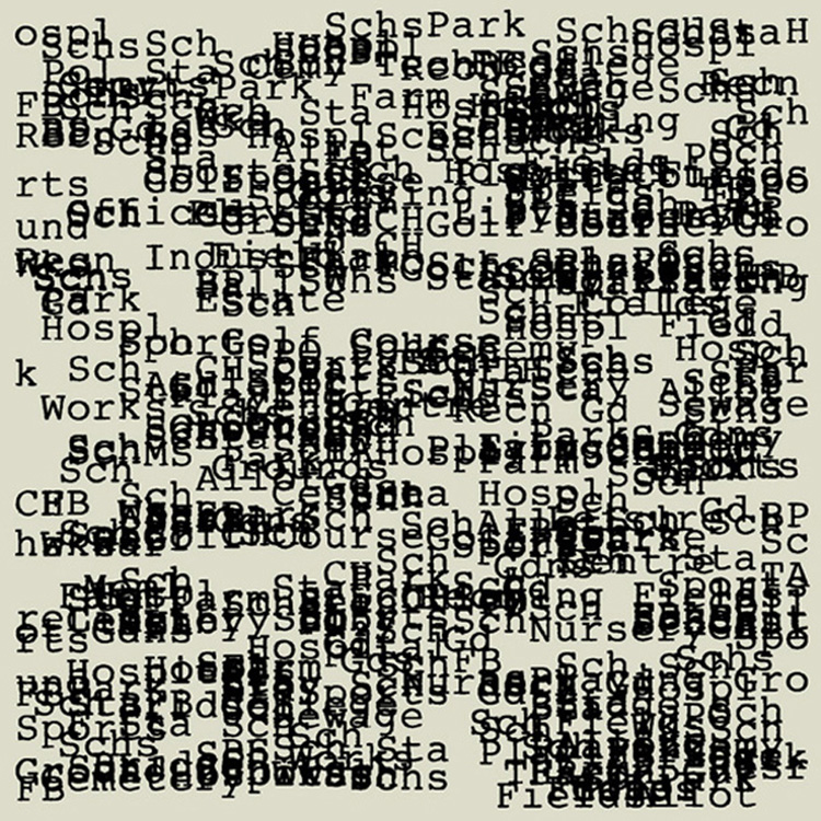
Terms and abbreviations from the map of a suburban area measuring ten by ten kilometres: ‘TQ26, Ordnance Survey 1:25000 second series’. Each kilometre square is superimposed; the accumulative interference isolating each locational term from relationships within its own territory. The index records occurrences within the hundred squares. [1992/94]
...
The geography—a hundred square kilometres that are part of the London Boroughs of Sutton, Merton and Croydon—is
the area where I spent my childhood. It includes the schools, parks, libraries, etc., I went to, and the type of place with
which I was most familiar during my first twenty years. Ten or fifteen years later, when I was living in central London,
I would travel out to this area and walk from one familiar place to another. There seemed to me to be specific ideas of
connectedness, a psychological understanding of the way one location is related to another. Places are linked by roads
and people mainly travel from here to there by car, the bits in-between largely filled with houses and gardens, all making
a particular mental geography of the suburbs. This can perhaps be best understood in contrast to another isolative
perceptual geography: that of a single feature related to its particular topography, as in the case, for example, of a hill
farm in a rural landscape.
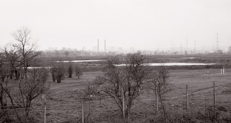
One part of this suburban landscape seemed anomalous, its ‘identity’ could be perceived as an ‘inverted wilderness’:
a large flat area bordering Mitcham, Carshalton, Croydon and Wallington—a square mile or so—of officially private
common-type land, gravel pits and ex-sewage workings. There is a network of paths and the whole area is fenced-off
(unofficial access is available about every few hundred yards). The area is used for riding motorbikes, rabbiting, watching
birds*, etc.; that is, marginal activities. Bounded on all sides by arterial roads and a railway line, from within the fenced-off area there is a feeling of detachment and in effect, invisibility. From a car one is aware of the perimeter and the power
lines that cross the area, and five miles away, on the horizon, you can see the buildings of central Croydon.
It seems to correspond to the opposite of the land beyond the medieval town walls—this perimeter containing the town
and keeping out the land, whereas here the ‘wild’ is an island within the suburban. Some largely hypothetical ideas of
orientation in landscape were provoked by being in this place—that there may exist a sort of historical and acoustical
‘depth’ in the place, a pre-electrical radio of invisible/inaudible sound.
* “...because of its undisturbed nature it is one of the best places for birdwatching in London. Although the fields are no longer regularly flooded... the ditches and settling tanks enable lapwing and redshank to breed there, whilst the fields
provide winter feeding grounds for gulls, lapwings and starlings.”
The River Wandle, a guide and handbook, Sutton, Surrey 1974.